- India
- Apr 13
Explainer / Monitoring of earthquakes
An earthquake of magnitude 3.5 with epicentre in Delhi shook the region on April 12 evening, prompting panic-stricken people to rush out of their homes.
According to the National Centre for Seismology (NCS), the quake occurred at 5.45 pm. The tremors were also felt in neighbouring Noida, Ghaziabad and Faridabad. There were no reports of loss of life or damage to property.
It is rare that Delhi has been the epicentre of an earthquake. The city, however, feels tremors when a quake occurs even as far as central Asia or in the Himalayan range, which is a high seismic zone.
Monitoring of earthquakes
The history of instrumental earthquake monitoring in India dates back to 1898, when the first seismological observatory of the country was established at Alipore (Calcutta) on December 1, 1898 after the great Shillong plateau earthquake of 1897.
The occurrence of devastating earthquakes such as the 1905 Kangra earthquake, 1934 Nepal-Bihar, Assam and many other strong earthquakes, necessitated to strengthen the national seismological network progressively from a paltry 6 in 1940 to 8 in 1950, 15 in 1960 and 18 in 1970.
Early 1960s marked a very important landmark in the history of seismic monitoring, when the World Wide Standardized Seismic Network (WWSSN) stations started functioning globally.
National Center for Seismology
National Center for Seismology (NCS) is the nodal agency of the government of India for monitoring earthquake activity.
NCS maintains a National Seismological Network (NSN) for real time monitoring of earthquake activities in and around the country. The NSN consists of 84 state-of-art digital broadband seismograph stations with VSAT commutations facilities for real time monitoring and auto location of earthquakes in and around the country.
This system has latest tools for dissemination of earthquake information to the concerned disaster management authorities and other user agencies in least possible time (8-10 minutes) for relief and rescue operations in hour of need.
Apart from earthquake monitoring, NCS is also actively involved in the Seismic Hazard Microzonation and seismological research.
Major activities of NCS are:
* Earthquake monitoring on 24x7 basis.
* Operation and maintenance of National Seismological Network.
* Maintenance of seismological data centre and information services.
* Seismic hazard microzonation related studies.
* Aftershock/earthquake swarm monitoring/survey.
* Understanding of earthquake processes.
* Public outreach.
Mobile app
In 2017, NCS launched a mobile app — India Quake — for automatic dissemination of earthquake parameters (location, time and magnitude) after the occurrence of earthquakes. The app will make information dissemination faster with no restrictions on the number of recipients. Any citizen can download this app and get the real time earthquake location information on mobile. It will help in reducing panic amongst people during an earthquake. For example, if an earthquake occurs in Hindukush region, Afghanistan and is strongly felt in Delhi, then people in Delhi will know in less than two minutes that the earthquake has actually occurred in Afghanistan and not in Delhi.
Seismic zones in India
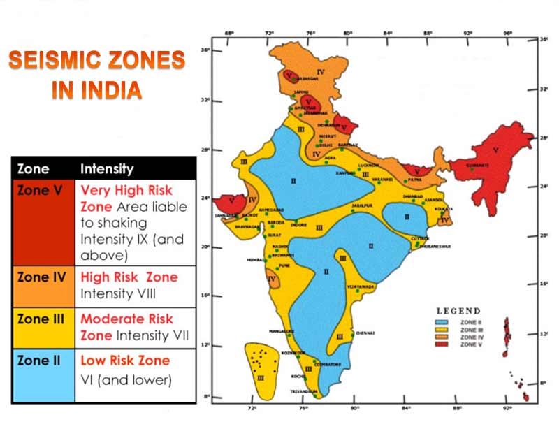
The Bureau of Indian Standards, based on the past seismic history, grouped the country into four seismic zones:
Zone-II (Low intensity zone)
Zone-III (Moderate intensity zone)
Zone-IV (Severe intensity zone)
Zone-V (Very severe intensity zone)
Broadly, Zone-V comprises the entire northeastern region, parts of Jammu & Kashmir, Himachal Pradesh, Uttaranchal, Rann of Kutch in Gujarat, parts of North Bihar and Andaman & Nicobar Islands.
Zone-IV covers the remaining parts of Jammu & Kashmir and Himachal Pradesh, Delhi, Sikkim, northern parts of Uttar Pradesh, Bihar, West Bengal, parts of Gujarat, some portions of Maharashtra near the west coast and Rajasthan.
Zone-III comprises of Kerala, Goa, Lakshadweep islands, remaining parts of Uttar Pradesh, Gujarat and West Bengal, parts of Punjab, Rajasthan, Madhya Pradesh, Bihar, Jharkhand, Chhattisgarh, Maharashtra, Odisha, Andhra Pradesh, Tamil Nadu and Karnataka.
Zone-II covers the remaining parts of the country.
Some terms related to earthquake
Earthquake: Earthquake is the manifestations of sudden release of strain energy accumulated in the rocks over extensive periods of time in the upper part of the Earth. Earthquakes are classified as, Slight (M<5.0), Moderate (5.0<M<6.9) and Great (M>7.0) depending upon the magnitude on Richter scale. An earthquake having a magnitude, M<2.0 is termed as a microearthquake.
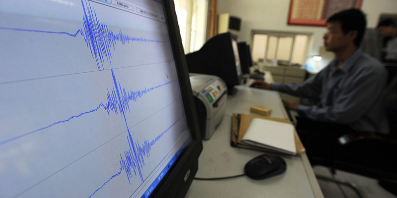
Seismograph: A seismograph, or seismometer, is an instrument used to detect and record earthquakes. Generally, it consists of a mass attached to a fixed base. During an earthquake, the base moves and the mass does not. The motion of the base with respect to the mass is commonly transformed into an electrical voltage. The electrical voltage is recorded on paper, magnetic tape, or another recording medium. This record is proportional to the motion of the seismometer mass relative to the earth, but it can be mathematically converted to a record of the absolute motion of the ground. Seismograph generally refers to the seismometer and its recording device as a single unit.
Richter scale: The Richter magnitude scale was developed in 1935 by Charles F. Richter of the California Institute of Technology as a mathematical device to compare the size of earthquakes. The magnitude of an earthquake is determined from the logarithm of the amplitude of waves recorded by seismographs. Adjustments are included for the variation in the distance between the various seismographs and the epicenter of the earthquakes. On the Richter Scale, magnitude is expressed in whole numbers and decimal fractions. For example, a magnitude 5.3 might be computed for a moderate earthquake.
Epicenter: It is the point on the surface of the Earth, vertically above the place of origin (hypocenter or focus) of an earthquake.
Aftershock: An earthquake that follows a large magnitude earthquake called, “main shock” and originates in or around the rupture zone of the main shock. Generally, major earthquakes are followed by a number of aftershocks, which show a decreasing trend in magnitude and frequency with time.
Manorama Yearbook app is now available on Google Play Store and iOS App Store


