- India
- May 29
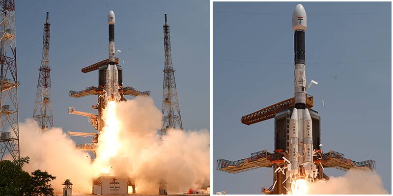
ISRO successfully launches navigation satellite NVS-01
• The Indian Space Research Organisation (ISRO) successfully launched NVS-01, a second generation navigation satellite, and placed it into Geosynchronous Transfer Orbit (GTO).
• NVS-01 would augment the country’s regional navigation system, providing accurate and real-time navigation.
• The 51.7 metre tall, 3-stage Geosynchronous Satellite Launch Vehicle (GSLV) lifted off at a prefixed time of 10.42 am from the second launch pad at Sriharikota.
• NVS-01 carried navigation payloads L1, L5 and S bands and the second generation satellite also has an indigenously developed rubidium atomic clock.
• It is for the first time that an indigenously developed rubidium atomic clock has been used as the scientists earlier opted for imported ones to determine date and location.
• Ahmedabad-based Space Applications Centre has developed the clock. It assumes significance as it is an important technology that only a handful of countries possess.
• The mission life of NVS-01 is expected to be better than 12 years.
• The second generation navigation satellite series dubbed as a significant launch would ensure the continuity of NavIC (Navigation with Indian Constellation) services, an Indian regional satellite navigation system, similar to the GPS, providing accurate and real-time navigation.
• ISRO has already launched similar navigation satellites — IRNSS-1A,IRNSS-1B,IRNSS-1C, IRNSS-1D, IRNSS-1E,IRNSS-1F,IRNSS-1G, IRNSS-1H and IRNSS-1I.
• Of these missions, IRNSS-1H was not successful as the satellite could not be placed into orbit. It was replaced by IRNSS-1I which was successfully launched on April 12, 2018.
Navigation with Indian Constellation (NavIC)
• The Navigation with Indian Constellation (NavIC) is the Indian Regional Navigation Satellite System (IRNSS) developed by Indian Space Research Organisation (ISRO).
• It is an independent regional navigation system designed to provide accurate position information service to users in India as well as the region extending up to 1,500 km from its boundary, which is its primary service area.
• IRNSS is envisaged to provide two types of services — Standard Position Service (SPS) for civilian users and Restricted Service (RS) for strategic users.
• NavIC provides a position accuracy of better than 20 m in the primary service area.
• NavIC can be extensively used for positioning, navigation and timing applications in a variety of civil and commercial activities.
NavIC SPS signals are interoperable with the US global navigation satellite system signals, GPS, GLONASS (Russia), Galileo (European Union) and BeiDou (China).
Some applications of NavIC are:
• Terrestrial, aerial and marine navigation
• Disaster management
• Vehicle tracking and fleet management
• Integration with mobile phones
• Precise timing
• Mapping
• Terrestrial navigation aid for hikers and travellers
• Visual and voice navigation for drivers.
What is Global Positioning System (GPS)?
• The Global Positioning System (GPS) is a US-owned utility that provides users with positioning, navigation, and timing (PNT) services. This system consists of three segments: the space segment, the control segment, and the user segment. The US Air Force develops, maintains, and operates the space and control segments.
• The GPS space segment consists of a constellation of satellites transmitting radio signals to users. The US is maintaining the availability of at least 24 operational GPS satellites.
• GPS has its origins in the Sputnik-era when scientists were able to track the satellite with shifts in its radio signal known as the “Doppler Effect”. The US Navy conducted satellite navigation experiments in the mid 1960s to track US submarines carrying nuclear missiles. With six satellites orbiting the poles, submarines were able to observe the satellite changes in Doppler and pinpoint the submarine’s location within a matter of minutes.
• In the early 1970s, the Department of Defence (DoD) wanted to ensure a robust, stable satellite navigation system would be available. Embracing previous ideas from Navy scientists, the DoD decided to use satellites to support their proposed navigation system. DoD then followed through and launched its first Navigation System with Timing and Ranging (NAVSTAR) satellite in 1978. The 24 satellite system became fully operational in 1993.
• Today, GPS is a multi-use, space-based radionavigation system owned by the US government and operated by the US Air Force to meet national defence, homeland security, civil, commercial, and scientific needs. GPS currently provides two levels of service: Standard Positioning Service (SPS) and Precise Positioning Service (PPS). Access to the PPS is restricted to US Armed Forces, US federal agencies, and selected allied armed forces and governments. The SPS is available to all users on a continuous, worldwide basis, free of any direct user charges.
Additional read:
Other global navigation networks
The BeiDou Navigation Satellite System (BDS) has been constructed and operated by China with an eye to the needs of the country’s national security. Galileo is the European Union’s Global Satellite Navigation System (GNSS). Like the other global systems, Galileo provides radio signals for position, navigation and timing purposes.
Manorama Yearbook app is now available on Google Play Store and iOS App Store


