- India
- Dec 06
Explainer - What is Gram Manchitra?
• The ministry of panchayati raj launched the geographic information system (GIS) application “Gram Manchitra” (grammanchitra.gov.in) in October 2019 to encourage spatial planning by Gram Panchayats.
• In a written reply in Lok Sabha on December 5, the Union Minister of State for Panchayati Raj Kapil Moreshwar Patil explained about new features added to the application.
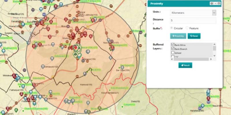
• Gram Manchitra provides a single/unified geo-spatial platform to better visualise the various developmental works to be taken up across different sectors and provide a decision support system for Gram Panchayat Development Plan (GPDP).
• The panchayats can utilise this to plan, develop and monitor developmental activities on a real time basis.
What is a geographic information system (GIS)?
• A geographic information system (GIS) is an online system that analyses and displays geographically referenced information. It uses data that is attached to a unique location.
• GIS is used to store, visualise, analyse and interpret geographic data. Geographic data (spatial or geospatial) identifies the geographic location of features.
• These data include anything that can be associated with a location, or more simply anything that can be mapped. For example, roads, country boundaries, and addresses are all types of spatial data.
Highlights of Gram Manchitra:
The application is being integrated with spatial and non-spatial data from various ministries, which include:
i) District hospitals, sub-district hospitals, Common Services Centres and sub-centres (ministry of health and family welfare).
ii) Banking amenities like bank branches, ATM, banking correspondence, etc (ministry of finance).
iii) Postal facilities (ministry of communication).
iv) Schools (department of school education & literacy).
v) Fair price shops (ministry of consumer affairs, food & public distribution).
vi) Drinking water sources (ministry of drinking water and sanitation).
vii) MGNREGA assets data (ministry of rural development).
• This application is also linked with the Socio-Economic Caste Census (SECC) report and Mission Antyodaya. All this information is available in a single window, which will assist the Gram Panchayat user in better visualisation of works during planning.
• Real time monitoring of activities or development work implementation status and progress of execution of various schemes can be easily tracked.
• Analysis tools like proximity analysis, measurement tool, query, elevation profile, panchayat profile, etc have been provisioned in the application to support the users for prioritising the activities as per the available infrastructure.
• Further, the ministry has launched mActionSoft, a mobile based solution to help in capturing photos with geo-tags (GPS coordinates) for the works which have asset as an output.
• Geo-tagging of the assets is done in all three stages — before start of the work, during the work and on completion of work. This would provide a repository of information on all works and assets related to natural resource management, water harvesting, drought proofing, sanitation, agriculture, check dams and irrigation channels, etc.
• Assets geo-tagged using the m-ActionSoft application is available on Gram Manchitra, enhancing the visualisation of various developmental works in the Gram Panchayats.
• The assets created under the finance commission funds are geo-tagged with the photographs of assets by panchayats. The GIS data of assets geotagged on the map of Panchayat can be visualised on the Gram Manchitra application.
Manorama Yearbook app is now available on Google Play Store and iOS App Store

