- India
- May 28
- Sreesha V.M
What is Digital Postal Index Number (DIGIPIN)?
• The Department of Posts launched two digital platforms marking a significant step towards the modernisation of India’s addressing system and geospatial governance.
• These platforms are — ‘Know Your DIGIPIN’ and ‘Know Your PIN Code’.
• These platforms were launched in alignment with the National Geospatial Policy 2022, which envisions the development of an advanced geospatial infrastructure to support digital governance and public service delivery.
DIGIPIN
• The Digital Postal Index Number (DIGIPIN) is an open-source, interoperable, geo-coded, grid-based digital address system developed by the Department of Posts in collaboration with IIT Hyderabad and NRSC, ISRO.
• It is a cornerstone of the Department of Posts’ vision to offer Address-as-a-Service (AaaS) — an array of services associated with address data management to support secure and efficient interactions between users, government entities, and private sector organisations.
• Incorporating DIGIPIN as an additional address attribute enables laying the foundation for future GIS-based digitalisation of service delivery across various organisations in a cost-effective manner.
• It would enhance location accuracy across various sectors by providing precise geographic coordinates, ensuring accurate service delivery and reducing emergency response times.
• A standardised geo-coded addressing system would enhance India’s geo-spatial ecosystem. It would add to the geospatial knowledge stack of the country in line with the National Geospatial Policy 2022, which seeks to strengthen the geospatial sector to support national development, economic prosperity and a thriving information economy.
• DIGIPIN is visualised as an alpha numeric offline grid system that divides the geographical territory of India into uniform 4-meter by 4-meter(approx.) units.
• Each of these 4m x 4m units (approximately) is assigned a unique 10-digit alphanumeric code, derived from the latitude and longitude coordinates of the unit. This alphanumeric code serves as the offline addressing reference for any specific location within the DIGIPIN system.
• DIGIPIN is thus strictly a function of the latitude and longitude of the location represented as a grid value. The system is designed to be scalable, adaptable, and integrated with existing GIS applications.
Key features of ‘Know Your DIGIPIN’ portal include:
i) Retrieving a DIGIPIN based on exact geolocation.
ii) Converting latitude-longitude coordinates into DIGIPINs and vice versa.
iii) Enhancing logistics, emergency response, and service delivery, particularly in rural and remote areas.
What is PIN Code?
• The PIN Code system was introduced in India by Shriram Bhikaji Velankar, who had served as an additional secretary in the Union ministry of communications.
• Its implementation began from August 15, 1972.
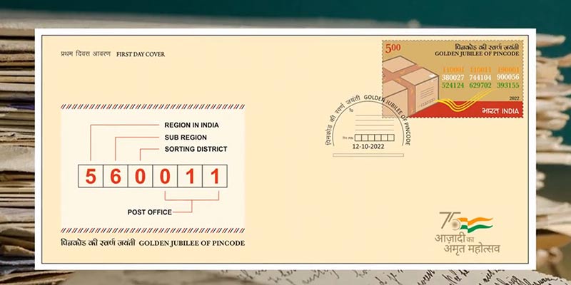
• Postal Index Number (PIN) or PIN Code is a six digit code of post office numbering used by India Post.
Why was the PIN Code introduced?
• There was confusion resulting from the duplication of names of various places across the country. Also, multiple languages were used to write addresses.
• The PIN code aims to simplify sorting of mails, speeding up mail transmission and delivery.
What does the PIN Code mean?
• There are nine PIN regions in the country. The first eight are geographical regions and the digit 9 is reserved for the Army Postal Service.
• The first digit indicates one of the regions. The first two digits together indicate the sub-region or one of the postal circles.
• The first three digits together indicate a sorting/revenue district.
• The last three digits refer to the delivery post office.
(The author is a trainer for Civil Services aspirants.)


